| Hurricane Michael - Hurricane Michael Webcams, News & Discussion |
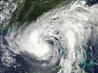
 | Hurricane Michael
Popularity:  
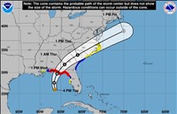
Hurricane Michael is strengthening as it approaches Florida's panhandle as a category 3 major hurricane with maximum sustained winds of 120 MPH. It is expected to cross Florida, Georgia and South Carolina before exiting over the Outer Banks of North Carolina sometime Thursday.
The Outer Banks are expected to get winds between 70 - 80 MPH. Updates will be posted as the hurricane's path becomes more clear. |
 |
| Hurricane Matthew - Hurricane Matthew Webcams, News & Discussion |
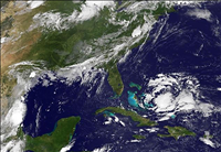
 | Hurricane Matthew
Popularity:
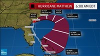
UPDATE 10/8/2016 7:20 AM
Saturday - Hurricane Matthew is currently hammering coastal South Carolina it looks set to start looping back toward Florida tonight. The Outer Banks of North Carolina may get a reprieve as the new storm models have Matthew veering south east into open water before turning back toward southern Florida.
Matthew is having significant impacts along the Southeast U.S. with coastal flooding and widespread power outages. All interests in the coastal Southeast states sho... |
|
| Tropical Storm Karen - Tropical Storm Karen Webcams, News & Discussion |
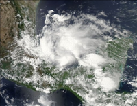
 | Tropical Storm Karen
Popularity:
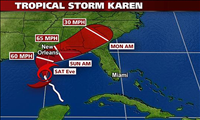
UPDATE - 10/4/2013
Tropical Storm Karen has weakened a bit, but still poses a threat to the Gulf Coast. The updated projections for the storm path have it taking an angled approach and affecting Alabama and Florida's Panhandle region Saturday. More updates to come.
Tropical Storm Karen has formed in the Gulf of Mexico and threatens the Gulf Coast of Florida, Alabama and Louisiana. The current forecast of the projected path has cause hurricane watches to be issued for coastal areas including ... |
|
| Tropical Storm Dorian - Tropical Storm Dorian Webcams, News & Discussion |
 | Tropical Storm Dorian
Popularity:
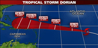
UPDATE 7/25/2013 12:00 PM - Dorian has become a disorganized tropical wave and will not likely regain strength due to unfavorable conditions.
Tropical Storm Dorian has maintained its strength Thursday, after quickly intensifying Wednesday. Dorian, is the fourth named Atlantic system of the year and formed over the far eastern Atlantic Ocean, southwest of the Cape Verde Islands.
Dorian will continue tracking west-northwest over the next several days on the south side of the Bermuda-Azores ... |
|
| Tropical Storm Chantal - Tropical Storm Chantal Webcams, News & Discussion |
 | Tropical Storm Chantal
Popularity:
UPDATE 7/9/2013 3:30 PM - It now looks as though T.S. Chantal will weaken over the next 72 hours as it approaches the East coast of Florida. It will likely bring wind, rain and rough surf to East Coast beaches from Miami to Daytona by Saturday.
Much faster than expected, Tropical Storm Chantal formed in the tropical Atlantic Ocean late Sunday night. TS Chantal is currently threatening the Lesser Antilles and is then expected to affect portions of the Dominican Republic, Haiti, and Cuba.
T... |
|
| Tropical Storm Barry - Tropical Storm Barry Webcams, News & Discussion |
 | Tropical Storm Barry
Popularity:
On 6/19/2013, Tropical Storm Barry moved inland into the Mexican state of Veracruz on the morning of June 20, 2013 with heavy rain. |
|
| Tropical Storm Andrea - Tropical Storm Andrea Webcams, News & Discussion |
 | Tropical Storm Andrea
Popularity:
UPDATE 6/8/2013 10:30 AM - The remnants of TS Andrea are causing flooding problems for much of the east coast.
UPDATE 6/7/2013 8:00 AM - TS Andrea is losing a bit of steam as it quickly starts its run up the Eastern seaboard. High winds, heavy rain and possible tornadoes are still a threat for Virginia and other coastal states in her path.
UPDATE 6/6/2013 4:30 PM - TS Andrea will make landfall in the Big Bend area of the Florida Panhandle shortly and will be near Charleston, SC by 8:00 AM... |
|